This is a 6 mile class V run in Escalante Canyon between Delta and Grand Junction, CO. Don't get it confused with its namesake in Utah. This is an early season favorite for kayakers around Colorado. At low water it can be made manageable for a class IV boater, but when it's flooding, it's full on class V. The run ends in a beautiful 1/4mi long gorge that is the steepest part of the run.
For a very very rough indication of the flow on this run, take the difference between the gauges on the Gunnison at Delta and Grand Junction. If the difference is greater than 1000 cfs, beg/bribe/forcefully coerce someone to get a visual, as there's a decent chance Escalante Creek is running.
http://www.cbrfc.noaa.gov/station/flowplot/flowplot.cgi?gjnc2
http://www.cbrfc.noaa.gov/station/flowplot/flowplot.cgi?delc2
Best indication of snowpack in the area:
Columbine Pass Snotel , https://wcc.sc.egov.usda.gov/nwcc/site?sitenum=409
This is very much a guess, but I have notes that say a rate of change in SWE at Columbine Pass of -1.0" per day equates to a low flow on Escalante.
| KSC | |
| Class | IV+ to V |
| Current Flow | Visual or Unknown |
| Recommended Flow |
Minimum: 150.0 Average: 350.0 Maximum: 1000.0 |
| Typical Season |
Begins: March Ends: July |
| Recommended Use |
Kayaking: Yes Rafting: No Canoeing: No SUP: No Packrafting: No Fishing: No |
| Primary Gauge | VISUAL |
| Length | 6.0 Mile(s) |
| Gradient | FPM |
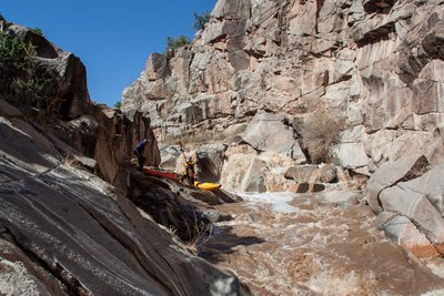
Escalante Falls
04-09-2013 - low water
Photo By: Kevin Cripps
Subject: Jake Vos, Bridger Steele