The Rogue River is located in southwestern Oregon and flows 215 miles from Crater Lake to the Pacific Ocean. The 84 mile, Congressionally designated "National Wild and Scenic" portion of the Rogue begins 7 miles west of Grants Pass and ends 11 miles east of Gold Beach. The Wild section of the Rogue, which is 36 mile, is permitted by the Bureau of Land Management from May15 to October 15, but the river is generally run-able all year. The lottery occurs December 1 to January 31 cancellations are given over the phone starting May 5. The Rogue flows through the Siskiyou mountains and is considered a premier fishing river. It is considered to be a class III+ river the major rapids are Rainie falls and Blossom Bar. Rainie has a small by-pass channel known as the fish ladder, Blosom is a complex rapid that is a mandatory scout.
There are several wilderness lodges on the Rogue so you can do a late season fishing trip. The lodges are heavily used by outfitters so be sure to inquire months in advance if you wish to do a lodge trip.
| Mary Zuschlag | |
| Class | III to IV |
| Current Flow |
2200.0 CFS 06-12-2026 12:30 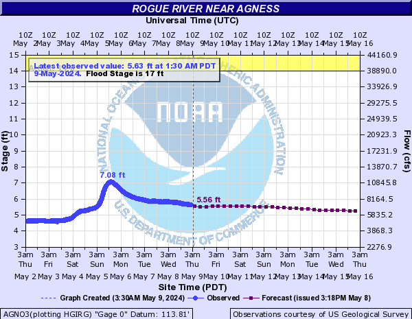
View River Forecast |
| Recommended Flow |
Minimum: 700.0 Average: 1500.0 Maximum: 35000.0 |
| Typical Season |
Begins: January Ends: December |
| Recommended Use |
Kayaking: Yes Rafting: Yes Canoeing: Yes SUP: No Packrafting: No Fishing: Yes |
| Primary Gauge | ROGUE RIVER NEAR AGNESS, OR |
| Length | 36.0 Mile(s) |
| Gradient | 33.0 FPM |
