From Desert Voyagers
The most commonly run section of the Lower Verde River is run from Bartlett Lake Dam on down the river to a river access point (RAP) known Box Bar. While the river remains navigable beyond that point all the way down into the Salt River, passing that point means entering the Fort McDowell Indian Reservation. Boating into the reservation is strictly prohibited without proper permits. Contact representatives from the Apache Nation for further information. The classification of the river is Class I to Class II depending on current flow, and the most reliable water is in the spring. Less than an hour's drive from Phoenix to the put in, and 30 minutes from the take out it's a close day trip. Paddling from Riverside RAP below the dam to Box Bar takes most casual paddlers between 2 and 5 hours, and is a nice small step up from the Lower Salt Paddle.
Much of the flora and fauna is similar to the Lower Salt. The first half is towered over by cliffs close in and verdant riparian trees and bushes. By the end of the paddle, the desert opens up with Saguaro forests and cactus typical of the middle Sonoran Desert. Birds are many, particularly in the winter and spring months and include eagles, ospreys, herons and egrets. The eagles are particularly common, and cause one issue for boaters - shore closures. From Dec 1st to June 30th, areas of the shore are off limits to landing by any boat, so check out Tonto National Forest's site for specifics and know where you are at all times. The river also passes below Needle Rock, a popular recreation area particularly in the summer months. For the fisherman, Bartlett dam on both sides offers an opportunity for some large mouth fishing, and Game and Fish Department stocks Rainbow trout thoughout in the cooler seasons.
With less river traffic then the Lower Salt, and only slightly more technical water, the Lower Verde offers a great option for a change of pace and a scenic paddle!
| Dylan | |
| Class | I to II |
| Current Flow |
167.0 CFS 07-08-2026 18:30 |
| Recommended Flow |
Minimum: 300.0 Average: 500.0 Maximum: 2000.0 |
| Typical Season |
Begins: November Ends: April |
| Recommended Use |
Kayaking: Yes Rafting: Yes Canoeing: Yes SUP: No Packrafting: Yes Fishing: Yes |
| Primary Gauge | VERDE RIVER BLW BARTLETT DAM, AZ. |
| Length | 19.0 Mile(s) |
| Gradient | FPM |
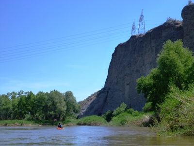
cliffs along the lower Verde
04-22-2017 -