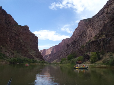
This run is also known as the Gates of Lodore and was run by the Powell expeditions in the 1800's. Since this run's flow is controlled by Flaming Gorge Dam the season runs all year. Permits are tough to come by but this run should be on your multi-day todo list.
| Class | III to III+ |
| Current Flow |
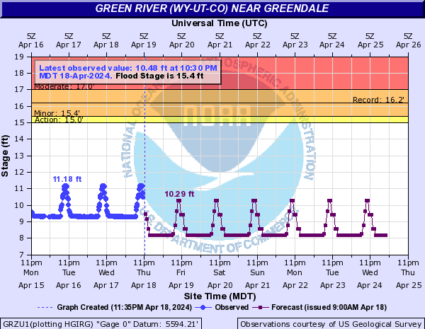
847.0 CFS 02-21-2026 21:30 
View River Forecast |
| Recommended Flow |
Minimum: 800.0 Average: 3000.0 Maximum: 6000.0 |
| Typical Season |
Begins: January Ends: December |
| Recommended Use |
Kayaking: Yes Rafting: Yes Canoeing: Yes SUP: No Packrafting: No Fishing: Yes |
| Primary Gauge | GREEN RIVER NEAR GREENDALE, UT |
| Length | 19.0 Mile(s) |
| Gradient | 14.0 FPM |

Gates of Lodore
08-25-2011 - Entering the canyon
| Permit Agency Name | Dinosaur National Monument River Office |
| Permit Agency Phone Number | Launch Info 1-866-825-2995 |
| Permit Agency Address |
4545 Highway 40 Dinosaur, CO 81610 |
| Permit Information |
2010 Fee Schedule $15.00 - Application Fee $185.00 - Multi-Day Permit Fee $20.00 - One-Day Permit Fee $35.00 - Over-length Trip Fee High use lottery applications will be accepted November 2, 2009, to February 1, 2010. All applicants will benotified of results by February 27, 2010. Low use, low water, one-day trips, and any available high use trips areavailable for reservation beginning March 1, 2010. For river permit information, applications, regulations, andcancellations, call the River Office at (970) 374-2468 between 8:00 a.m. and 12:00 p.m. mountain time, Mondaythrough Friday. Do not call the main visitor number for river permit information – calls cannot betransferred to the River Office. Mail application to Dinosaur National Monument, River Office, 4545 Highway 40,Dinosaur, Colorado 81610. |
| Permit Regulations and Required River Gear |
|
| Permit Agency URL | http://www.nps.gov/dino/planyourvisit/permits.htm |
| Application Deadline | February 1 |
| Application Fee | $15.00 |
| Permit Fee |
| Type | Name | Description | Camping? | Water? | Boat Ramp? | Vehicle Access |
|---|---|---|---|---|---|---|
| Put-In | Lodore Ranger Station |
Permit required to put-in or take-out here. Water is available during high season. Plenty of camp sites. Outhouses. As of 2013, the ramp is too far from the river due to sand bar and all boats have to be carried to the water. No trucks with trailers allowed on sand bar. |
Yes | Yes | Yes | All Vehicles |
| Take-Out | Echo Park | No | No | Yes | All Vehicles |
| Rapid Name | Description | Scout | Class | Recommended Flow |
|---|---|---|---|---|
| Hells Half Mile |
Enter left of center and then work right through the boulders. Watch for Lucifer's Rock midway down the rapid. You can run on the left or right of Lucifers but definitely avoid hitting it. |
Scout from river left by landing above the rapid. |
III to IV |
Minimum: 1000.0 Maximum: 5000.0 |
| Winnies Rapid |
read and run |
II |
Minimum: Maximum: |
|
| Upper Disaster Falls |
Disaster Falls recieves its name due to the Powell party losing a boat here in the 1869 expedition. This rapid is boulder lined so pick your line carefully throughout. The top section has a drop in section followed by some shallows. You then need to thread the needle between a large river right rock and rocks on the river left. |
Scout river left from the large eddy |
III to III+ |
Minimum: 1000.0 Maximum: 5000.0 |
| Lower Disaster Falls |
This is another rock filled rapid similar to upper disaster. Stay on river left and avoid the rocks and undercut on the river right channel. |
A beach landing exists above this rapid on river left you can scout from. |
III to III+ |
Minimum: 1000.0 Maximum: 5000.0 |
| Harp Falls |
Pull over and scout from river left. |
III to III+ |
Minimum: 1000.0 Maximum: 5000.0 |
|
| Triplet Falls |
This is a rock/boulder slalom course. Many think this is the most technical rapid in Lodore Canyon. |
Scout from triplet camp on river left or pull in on river left a little below the camp and scout. Watch out for poison oak in this area. |
III to III+ |
Minimum: 1000.0 Maximum: 5000.0 |
| Unnamed Rapid |
An easy class II rapid. Rocks in the center. |
Read and run |
II to II+ |
Minimum: 1000.0 Maximum: 5000.0 |
| Unnamed Rapid |
An easy class II riffle with some waves |
Read and run |
II |
Minimum: 1000.0 Maximum: 5000.0 |
| Camp Name | Description | Fee? | Beach? |
|---|---|---|---|
| Wade and Curtis Camp |
No beach, but plenty of tree cover. The landing is a little steep. Very short distance from put in, which is nice no serious rigging required on day 1. |
No | Yes |
| Kolb Camp |
on river right |
No | Yes |
| Pot Creek Camps |
Multiple sites here that can accommodate small or large groups. On river right. |
No | Yes |
| Triplet Camp |
on river left |
No | Yes |
| Limestone Camp |
On river left. Great covered camp, hike up the Limestone canyon. Has a nice beach, plenty of tree cover. 30 minutes to confluence. |
No | Yes |
| Ripling Brook Camps |
A couple of camps on river right. These are excellent camps (especially at lower water). Very nice tree cover |
No | Yes |
| Lodore Campground |
By the put-in |
No | No |
| Wild Mountain Camp |
on river right |
No | No |
| Echo Park Campsites | No | No | |
| Compromise |
Compromise is one of the few Grand Canyon style camps in dinosaur....pull in, park, set up the kitchen in front of the boats |
No | Yes |
The following fish species are often found on this run. If you don't see a fish that you know lives on this river, please login and associate that fish species.
| Fish Name | Description |
|---|---|
| Brown Trout |
Brown Trout have a yellowish belly, with black and red spots on the sides. This fish is a fresh, coldwater fish and is found all over. |
| Name | Type |
|---|---|
| Winnie's Grotto | Landmark |
| Steamboat Rock | Landmark |
| Steamboat Petroglyphs | Petroglyph |
| Mitten Fault | Geological Formation |
No external links or resources added yet...
No community notes added yet...
No Accidents reported for this run...
No River Shuttle Companies added yet...
No River Outfitters, Guides or Commercial Companies added yet...
No Camping or Lodging locations added yet...
