|
Four Falls (aka Foley Falls)
|
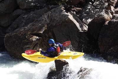
This rapid consists of four distinct drops. The first drop sets the class V rating. The remainder of the drops are class IV in nature.
The first drop is frequently portaged due to a significant amount of water pouring into cut out rock on river left. Although the move is class IV, the consequences are class V. Most people portage but the rapid is still run frequently and although life threatening situations seem to be rare, beatdowns in the hole occur regularly and almost always result in an out of boat experience that takes the swimmer deep.
The second drop is a 3-4ft sloping drop ready to stern squirt any boater with a mistimed boof. Keep your weight forward, utilize a delayed boof stroke and be prepared for the often rocky runout.
The third drop is an easy boof normally run down the middle but a sloppy entrance can result in a hole surf.
The fourth drop is an easy and fun 3 foot boof.
|
Historically, it was thought that the land around Four Falls was private. We have Ian Foley to thank for correcting this mistake. He prompted a survey in June of 2013 that revealed the private land boundary starts a couple hundred yards upstream of the normal portage/scout eddy for Four Falls and all the land around Four Fall is public national forest land. As always, tread lightly and be respectiful of the land you pass through, but there are no longer any concerns about trespassing on private property at this rapid.
Four Falls can sneak up on the unsuspecting boater. When the canyon begins to tighten, keep an eye out for a decent sized eddy on river right. If you see a steep, more dramatic cliff wall on river left with a horizon line, you are likely approaching the first fall. There is a graded path to use for the portage and scout on river right.
|
V
|
Minimum:
Maximum:
|
|
The Steeps: Goal Post
|
The next mile of whitewater is generally lumped into a long set of rapids collectively called the Steeps. The first rapid of the Steeps starts out with a tight move between two boulders. If you don't like the move, alternatives are available.
|
The Steeps are rarely scouted.
|
IV- to IV
|
Minimum:
Maximum:
|
|
The Steeps: S-turn
|
The next major rapid in the Steeps section drops the most gradient of the set. The clean line starts river right and bends back to river left. Failure to move back left sends the boater off a small ledge into a bad pin spot. Stay with the current and move left at the bottom.
|
|
IV to IV+
|
Minimum:
Maximum:
|
|
The Steeps: Eddyhopper
|
The last major rapid in the Steeps is usually entered on river right, but be aware that at normal (lower) flows, there are some small rocks just above the water level that can knock an unsuspecting boater off line. At higher water, the first hole has punished many poor boofs with a sticky hole ride. This rapid contains some fun eddy hop moves midway through for those looking to make it more interesting.
|
|
IV- to IV
|
Minimum:
Maximum:
|
|
Supermax
|
After the steeps the action mellows out. Dodge some rocks and keep an eye out for Supermax. For the last several years, the last good eddy before Supermax has been marked by a cairn on river left. Keep your eyes peeled because this rapid can sneak up on you. For most, Supermax is the crux rapid of the run. The river makes a strange bend in the top half just above a nasty looking undercut. Most people who get too friendly with the undercut flush through, but I have heard reports of boaters getting stuck in their boats in the undercut and having to swim out.
The bottom half is run more frequently and is referred to affectionately as Tampax. Those who chose to skip the upper half have only run Tampax. Tampax should not be taken lightly either, but tends to be very forgiving for the amount of gradient it drops.
At high water, the undercut is less in play but the holes in Tampax become significant.
|
Scout along the obvious path on river left. Look for wild raspberries in the fall.
|
V- to V
|
Minimum:
Maximum:
|
|
Trashcan
|
Not long after Supermax, the river becomes a bit steeper again, marking the start of Trashcan. A couple of large rocks split the channel in half. Most people prefer to take the less rocky, but slightly more technical far left line, making a 90 degree turn at the bottom of the rapid back into the main flow. However, all the lines go here, just make sure to keep the cockpit right side up.
Stay heads up for the Speedtrap eddy 100 yards after Trashcan. The sharp eddyline punishes boaters with a poor roll.
|
|
IV- to IV
|
Minimum:
Maximum:
|
|
Deer Creek
|
After a number of fun rapids, Deer Creek comes in from river left and joins the South Platte. Although the creek is often missed by passing boaters, a massive rock plate leaning against the right canyon wall signals that Deer Creek rapid is approaching. Eddy out river left behind a huge boulder to scout. This rapid is steep, boats remarkably smoothly, but has been the site of some nasty injuries. I've heard multiple stories of shoulder dislocations caused by running the last two slides upside down. As an upcoming class IV boater, the first time I saw this rapid, I was terrified by the gradient, but after watching a couple successful runs I gave it a shot and instantly fell in love.
Multiple lines exist, but at normal flows a rock grind on the left side of the first slide is a favorite. At higher flows this rapid becomes more legit and worthy of a scout for most boaters.
|
|
IV+ to V-
|
Minimum:
Maximum:
|
|
Uppercut Undercut
|
After Deer Creek, you may think you're done, but don't fall asleep just yet. A small bend left to right into a narrow channel signals this drop that contains a boat sized undercut at lower flows. Boof right.
|
|
III+
|
Minimum:
Maximum:
|
|
Mystery Eddy
|
This is the last rapid on the run. A huge boulder presents itself on river left, funnelling all the water to the right side. Half way through the drop, the boater has a choice of going left into an eddy behind the boulder, or charging straight through the right channel. Catching the left "mystery eddy" is unequivocally fun for both the boater and the boaters behind, as they watch you disappear. Be aware that the rock that splits the lower channel, just below the mystery eddy, presents a potentially dangerous pin spot.
|
|
IV-
|
Minimum:
Maximum:
|