The Black Canyon or (Gunny Gorge) is an impressive scar in the land in Western Colorado. The Gunnison River has slowly dug this ditch to around 2000 Feet deep. The Black Canyon (above Chukar Trail) section is committing and makes for a wild adventure for the expert kayaker. Portages are tough and most drops have must make moves to avoid sweepers and other nasty features. For those that make this trip though it is a trip of a lifetime for most. The Gunny Gorge section (below Chukar Trail) is a classic class III overnight trip, with one of the most difficult sections simply being accessing the river at the bottom of the steep Chukar Trail.
Since this section is dam controlled you can find flows year round. Lower flows will make it more bony and harder and high flows will make it really pushy and sketchy.
The section below the National Park boundary (Gunny Gorge) is not as committing as in the park (Black Canyon). Mainly a class III run but still committing due to the remote nature. The listed rapids are all in the Gunny Gorge section.
| Class | III to IV- |
| Current Flow |
3630.0 CFS 05-19-2024 16:00 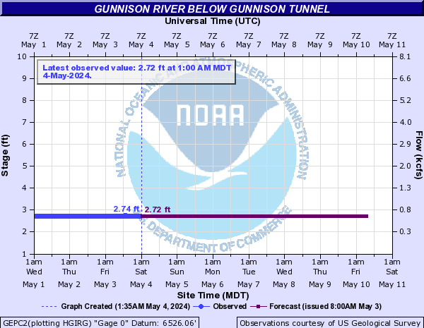
View River Forecast |
| Recommended Flow |
Minimum: 600.0 Average: 1100.0 Maximum: 2000.0 |
| Typical Season |
Begins: March Ends: October |
| Recommended Use |
Kayaking: Yes Rafting: Yes Canoeing: No SUP: No Packrafting: Yes Fishing: Yes |
| Primary Gauge | GUNNISON RIVER BELOW GUNNISON TUNNEL, CO |
| Length | 14.0 Mile(s) |
| Gradient | 50.0 FPM |
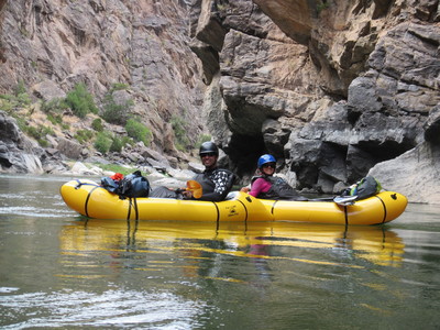
Packrafting on the Gunny Gorge
07-26-2014 -
Photo By: Laura Monthathong
